ENSC2022MORRILL27378 ENSC
Fighting food waste through community composting
Type: Undergraduate
Author(s):
Ashlyn Morrill
Environmental Sciences
Emily LeBlanc
Environmental Sciences
Camilla Price
Biology
Gloria Serrano
Environmental Sciences
Advisor(s):
Brendan Lavy
Environmental Sciences
Location: Second Floor, Table 5, Position 3, 11:30-1:30
View PresentationSince the 19th century, Earth’s average surface temperature has risen 2 degrees Fahrenheit due to an increase in the pollution of greenhouse gases caused by human activity. The magnitude of food waste produced in the United States contributes to climate change through the methane released by the excess food discarded in landfills. Each year, 40 percent of food in the United States is never consumed due to food loss or waste along the supply chain including growers, consumers, retailers, and restaurants (NRDC 2020; SOFA 2019). However, millions of Americans are food insecure or live in areas known as food deserts that have little access to fresh food. Recent estimates suggest 690 million people around the world went hungry in 2019 (UNICEF 2020). For food systems to operate more sustainably, we must promote food recovery processes, one of which is composting. The purpose of this research is to first quantify the amount of food waste produced and then diverted from landfills through a community composting program in Fort Worth, Texas. Our group has partnered with Roy Pope Grocery to collect composting material and deliver it to the UNT Health Science Garden, where it is weighed, processed, composted, and later used in gardening plots. Through composting, we are able to limit the amount of greenhouse gases emitted in the air, in turn, fighting climate change and preventing its negative impacts on Earth’s ecosystem. We are analyzing four months of food waste via descriptive statistics and the EPA’s Waste Reduction Model (WARM).
ENSC2022MUGISHA13032 ENSC
Fungal induced molecular transformation of plant-derived organic matter alters carbon sequestration potential and sorption capacity
Type: Undergraduate
Author(s):
Jesse Mugisha
Environmental Sciences
Advisor(s):
Omar Harvey
Geological Sciences
Location: Basement, Table 2, Position 1, 1:45-3:45
View PresentationMicrobial interactions with plant biomass contribute significantly to the cycling of nutrients and contaminants in the environment. Primarily among these interactions is the role of fungal-induced degradation of organic matter, its regulatory effects on the carbon cycle, and pollutant transport. This study uses fungal colonization of spent coffee grounds as a model for understanding fungi-plant biomass interactions and their relationship to carbon stability and pollutant removal capacity. Results indicate that fungal-induced alterations of the plant material result in an increase in aromatic and a concomitant decrease in methyl components of the organic matter. This molecular alteration was accompanied by an increase in the carbon content of the remaining material, an increase in the carbon stability as determined by the materials R , and an increase in sorption capacity for cationic species as determined from gentian violet sorption to the materials. The results from this study could contribute additional knowledge to solving grand challenges in climate and pollution.
ENSC2022PRICE46925 ENSC
Are all available water sources in an urban environment accessible to local bats?
Type: Undergraduate
Author(s):
Camilla Price
Environmental Sciences
Izzy Acheson
Environmental Sciences
Advisor(s):
Victoria Bennett
Environmental Sciences
Location: Basement, Table 11, Position 2, 1:45-3:45
View PresentationBats provide many ecosystem services, including pest control, pollination, and seed dissemination, which are economically beneficial to humans. Yet as human populations continue to grow, leading to the increasing loss, degradation, and fragmentation of natural habitats to urban sprawl, wildlife species including bats are having to adapt to this unnatural environment. One important resource that bats must access in such environments is water. In natural landscapes, bats drink from ponds, lakes, streams, rivers, and even puddles, but in human-modified areas, studies have shown that bats can drink from drainage ditches, cattle troughs, and residential swimming pools. However, it is generally assumed that these resources are not preferred and, if present, more semi-natural water sources, such as retention and ornamental ponds, would be preferentially used. But what if we are incorrectly assuming that all semi-natural water sources are readily accessible and available to bats. To explore this uncertainty, we conducted behavioral observation surveys using thermal cameras and acoustic detectors to determine whether semi-natural water sources within Fort Worth, including the retention pond on the Texas Christian University (TCU) campus, were suitable for bats. Specifically, we compared bat drinking activity at these ponds and identified pond characteristics that might deter or encourage bats to drink at them. Our study revealed that the presence of artificial lights represented a major characteristic that deterred bats. In particular, we found that only when flood lights from the TCU soccer field were turned off, bat activity was recorded at the TCU retention pond. This result confirmed that not all water sources are readily accessible and available to bats, but turning lights off when they are not needed could effectively improve water availability for bats. It is findings such as these that can inform the enrichment of urban environments for bats and, therefore, aid their conservation.
ENSC2022WASHINGTON18159 ENSC
E. Coli bacteria in our local streams: A case of the Village Creek in Everman, Texas
Type: Undergraduate
Author(s):
Morgan Washington
Environmental Sciences
Aria Tirion
Environmental Sciences
Advisor(s):
Gehendra Kharel
Environmental Sciences
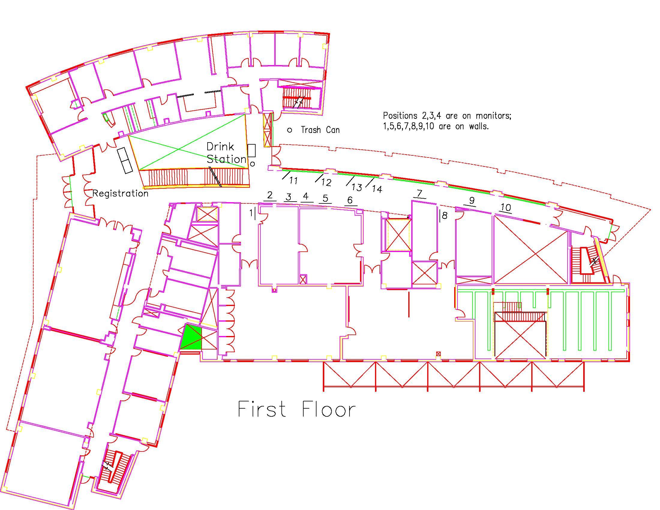
Location: First Floor, Table 5, Position 1, 11:30-1:30
View PresentationThe United States Environmental Protection Agency (US EPA) classifies nearly 28% of assessed rivers and streams in Texas as impaired due to pathogenic bacteria in the water. One such stream is the Village Creek, a tributary of the Trinity River in north-central Texas. Therefore, this study in the Water and Society Lab at TCU aims to monitor Escherichia coli (E. coli) concentration in the Village Creek.
In this ongoing study, we collect water quality samples weekly, incubate them for 24 hours at 35 °C, and then determine the presence or absence and total E. coli count as CFU (colony forming units) using the US EPA-approved Colilert system. E. coli over 126 CFU per 100 mL water sample indicates unsafe levels per the Texas Commission on Environmental Quality and the US EPA. Based on the analysis of 16 samples, the average, minimum, and maximum E. coli counts are 324.4 CFU, 15.5 CFU, and 1620 CFU, respectively. The next important step in this study is to build the statistical relationship of E. coli with different hydro-climatological variables, including streamflow, rainfall, ambient temperature, water temperature, pH, conductivity, and turbidity. The findings of this study will help make water quality and water resources management decisions in the north-central Texas region.
ENSC2021BLANCHE49931 ENSC
Do edge effects influence wildlife distributions in a small game reserve in South Africa?
Type: Graduate
Author(s):
Lyall Blanche
Environmental Sciences
Victoria Bennett
Environmental Sciences
Advisor(s):
Victoria Bennett
Environmental Sciences
Location: cancelled
(Presentation is private)Do edge effects influence wildlife distributions in a small game reserve in South Africa?
Lyall A. Blanché*1 and Victoria J. Bennett1
1Department of Environmental Science, Texas Christian University, Fort Worth, TX 76129 USA
Physical boundaries in the landscape can influence the abundance and distribution of species through edges effects, which are characterized as a behavioral response to features or boundaries, creating an area of avoidance known as edge habitat. The implication is a reduction in the amount of available habitat for an individual and/or its population. Studies have shown that anthropogenic features, such as roads and fences, can cause edge effects. Thus, should we be considering the consequences of anthropogenic edge effects when managing wildlife populations in game reserves? To address this, we used Global Positioning System point locations collected from 2004-2020 on cheetah, elephant, leopard, and lion in Amakhala Game Reserve, a 66 km2 fenced reserve in the Eastern Cape of South Africa. This reserve is bordered by a national highway and bisected by a public road. We used regression analysis to determine any relationship between the proportion of locations within 5 m increments and 1) the national highway, 2) public road, 3) boundary fence, 4) a river on the reserve, and 5) control sections of the reserve. Our analysis revealed a significant positive correlation between elephant locations and distance from the national highway, with elephants avoiding a 600 m wide section of the reserve next to the highway. Our study highlights the importance of identifying potential edge effects to better inform the management of small reserves.
ENSC2021GOULD17973 ENSC
Using GIS and Remote Sensing to Evaluate Flood Risk in Houston, Texas
Type: Graduate
Author(s):
Holly Gould
Environmental Sciences
Advisor(s):
Esayas Gebremichael
Geological Sciences
Location: Zoom Room 3, 03:19 PM
(Presentation is private)Globally, floods are the most common natural disasters, imposing stress on communities through infrastructure damage, financial costs, public health, and environmental damage. Serving as a major threat to the city of Houston, Texas (TX), this metropolitan area has an extensive flooding history. This project aims to develop a flood risk map for the White Oak Bayou Watershed, found in the North-East region of Houston. Using existing literature, the flood risk susceptibility for this study is based on seven factors: elevation, slope, flow accumulation, hydrologic classifications of soil, land use, rainfall, and distance to river networks. Using methods from existing literature, each individual factor was classified into 5 risk levels, based on their characteristics that make an area more prone to flooding. By using the weighted overlay analysis tool, the individual factors were weighted based on their contribution to overall flooding. The results show majority of the watershed is classified as medium risk, including areas of high and low flooding vulnerability. The high risk areas surround the river networks and increase risk towards the watershed’s discharge point, located in close proximity to the downtown area of Houston.
ENSC2021GOULD27766 ENSC
MODELING THE IMPACTS OF GREEN INFRASTRUCTURE IN THE VILLAGE CREEK WATERSHED, TEXAS
Type: Graduate
Author(s):
Holly Gould
Environmental Sciences
Advisor(s):
Gehendra Kharel
Environmental Sciences
Location: Zoom Room 4, 01:50 PM
(Presentation is private)Urbanization imposes threats to the quantity and quality of stormwater, driving communities to identify water management strategies that aid in sustainable development. As demand for urbanization increases, green infrastructure (GI) practices can be implemented as mitigation strategies, allowing for sustainable growth in communities with limited harm to water resources. This project will model the Village Creek (VC) watershed, a semi-urban watershed in north-central Texas, using the Soil Water Assessment Tool (SWAT) to estimate the effects of GI on water quantity and quality. Topographic, land cover, and soil data along with historical water quality and climate data drove the model, then GI designs influenced the transport of streamflow, bacteria, sediments, and nutrients. We expect the results to quantify changes in water quantity and quality from GI implementation and highlight the effectiveness of GI for the watershed. This research provides VCLA watershed managers and stakeholders information on environmentally sound and sustainable watershed protection planning.
ENSC2021LAWTON35350 ENSC
Exploring Premature Detachment of Radio-Transmitters used on Bats in Telemetry Surveys
Type: Undergraduate
Author(s):
Katie Lawton
Environmental Sciences
Victoria Bennett
Environmental Sciences
Advisor(s):
Victoria Bennett
Environmental Sciences
Mark Demarest
Biology
Becky Johnson
Environmental Sciences
Location: Zoom Room 3, 12:30 PM
View PresentationTo understand wildlife ecology, one common strategy is a technique known as telemetry. This technique involves attaching radio-transmitters to animals. For volant species, such as bats, transmitters are attached to their backs with an adhesive. However, one issue is that it is easy for the bats to remove the transmitter. The loss of transmitters early in surveys is not only costly, but limits the amount of data that can be collected. Thus, there is a real need to extend the length of time a transmitter remains on a bat. To address this, we conducted a two-part behavioral observation study in the bat flight facility at TCU. In part 1 from April to September 2019, we tested 1) two currently available transmitter brands and 2) three different prototype designs to determine if the overall shape and size of the transmitter impacted the length of time they remained attached. We found that regardless of transmitter brand or design, the antennas incurred a significant amount of damage, suggesting the bats used the antennas to grab and pull them off. Thus, for part 2 from August to September 2020, we conducted a series of trials to establish the effectiveness of three coatings at preventing bats from damaging the antennas. We found that transmitters did not remain attached significantly longer with cayenne pepper, nail-biting deterrent, or Tabasco sauce on the antenna, suggesting that either 1) bats were not deterred by the three coatings we selected, or 2) bats may not be chewing the antennas or putting them in their mouths to provide leverage to remove them. Overall, our study revealed that bats can and will remove transmitters by grooming them off using the antennas and recommend that future research focuses on integrating the antenna into the body of the transmitter as a preventative measure.
GEOL2021WILSON44110 ENSC
Analysis of River Flooding Impacts on the Trinity River in Tarrant County
Type: Undergraduate
Author(s):
Christopher Wilson
Geological Sciences
Meagan Alexander
Environmental Sciences
Advisor(s):
Esayas Gebremichael
Geological Sciences
Location: Zoom Room 5, 03:03 PM
(Presentation is private)Rivers are an essential part of any urban or rural landscape, providing drinking water, transportation, and recreational opportunities for local residents. However, with the continuous growth and development of urban areas like Fort Worth and Dallas, flooding poses a significant risk to human life and property. This increased development creates a need for careful monitoring and forecasting of river conditions and flood probabilities. This study explores the associated historical river data for USGS Gauges on the Trinity River in Tarrant and Dallas Counties. This data, along with topographic information and land use surveys, are used to project the possible impacts of flooding scenarios. These possible impacts include damage to property, critical infrastructure, and threats to human life. This data can then be interpreted spatially to effectively inform the public and public officials of risks and monetary costs associated with future flooding events.
ENSC2020AGPALO34894 ENSC
Improving habitats for bats: What makes a bat-friendly residential swimming pool?
Type: Graduate
Author(s):
Elizabeth Agpalo
Environmental Sciences
Advisor(s):
Victoria Bennett
Environmental Sciences
(Presentation is private)For urban environments to support bat communities, resources need to be readily available, such as water. For example, bats typically use urban water sources, such as drainage ditches, lakes, and ponds. However, in areas where temperatures are consistently high and rainfall limited, these sources tend to be ephemeral. During these periods, bats utilized residential swimming pools. If pools were more attractive to bats, we may be able to improve urban habitats for bats both in terms of abundance and species diversity. We, therefore, set out to determine whether size, shape (round of square), lighting, and treatment type (chlorine, salt, or mineral) encouraged bats to drink at pools. Thus, we conducted behavioral surveys at 14 pools using thermal cameras and acoustic detectors to record bat foraging and drinking activity. Our results demonstrated that while shape did not influence pool use, treatment type, lighting, and size did. With this information, we can better advise interested residents in urban neighborhoods how better to make their backyards more bat-friendly.
ENSC2020ISHIMWE15686 ENSC
The potential of cost-effective UAV technology to replace costly technologies in Precision Agriculture
Type: Undergraduate
Author(s):
Benite Ishimwe
Environmental Sciences
Advisor(s):
Esayas Gebremichael
Geological Sciences
View PresentationThe potential of cost-effective UAV technology to replace costly technologies in Precision Agriculture
Abstract
The use of satellite and aerial remote sensing for agricultural applications has exponentially expanded since the past decades. One such agricultural application that is highly dependent on the use of advanced hyperspectral and multispectral remote sensing and GPS technology to boost crop harvests and viability, while reducing the number and amount of inputs, like water, fertilizer, land, and others required to grow crops, is Precision Agriculture (PA). Although PA has been credited for the increased crop yield and productivity in the United States and worldwide, its dependence on costly technologies has been a major hurdle for it to be used by small-scale farmers locally and globally. This project aims to reduce the dependence of PA on costly and complex remote sensing technologies through the use of alternate and cheaper options such as low/medium-priced Unmanned Aerial Systems (UAV), popularly known as drones, equipped with only high-resolution cameras capable of, to a certain extent, mimicking the functionalities that are offered by costly technologies. Such low-cost technology is anticipated to enhance the efficiency and profitability of the agriculture sector through the provision of easier technologies to small-scale farmers. The research project is currently being implemented on a wheat farm owned by Davis farms (Grandview, Texas). Multi-temporal (at different growing stages) UAV imageries using DJI Mavic air 3D are being acquired with the purpose of producing 3D maps for qualitative and quantitative analysis. This includes crop-health assessment through the generation of crop-health indicator indices such as the Normalized Difference Vegetation Index (NDVI). A similar analysis from high-resolution multispectral imagery of the area, acquired from commercial satellite operators, will be undertaken and the accuracy, validity, and reliability of the UAV-based PA application will be assessed.
ENSC2020ISHIMWE6062 ENSC
The effects of increased population growth on Rwanda’s forest ecosystem
Type: Undergraduate
Author(s):
Benite Ishimwe
Environmental Sciences
Advisor(s):
Esayas Gebremichael
Geological Sciences
View PresentationThe effects of increased population growth on Rwanda’s forest ecosystem.
Rwanda is a country in Central-East Africa and one of the smallest countries on the African continental, being only 10,169 mi²/ 26340 sq. Km. Rwanda is a landlocked country bordered by Uganda, Tanzania, Burundi, and the Democratic Republic of the Congo. The current population of Rwanda is 12,830,205 as of 2020, based on the latest United Nations data with a population density of 525 per Km2 which equates to about 1,360 people per mi2 with 17.6 % of the population living in urban centers.
Rwanda forests have historically played a very significant role in the economy and livelihoods of its population through tourism, energy, and other industrial purposes. They provide around 86% of the primary energy source mainly as domestic cooking energy. Rwanda experienced 50.9% total forest loss since 1990, in order to address this deforestation and imbalance in wood supply/demand, Rwanda has over the years taken a consistent stance on increasing the forest cover by 30% by 2020. With growing population, this case study is going to analyze how population growth in Rwanda has affected forest cover and biodiversity. The study will integrate available geospatial datasets such as census, infrastructure, and satellite imagery to assess the impact of population growth on deforestation.
ENSC2020LAM11910 ENSC
Evaluating the Properties of Coffee Derived Carbon-Based Materials for the Removal of Lead from Contaminated Water
Type: Undergraduate
Author(s):
Amy Lam
Environmental Sciences
Advisor(s):
Omar Harvey
Geological Sciences
(Presentation is private)Americans generate about 12.6 million kilograms of spent coffee grounds every day. 90% of that will end up in a landfill. However, this waste stream is a potential starting material that can be used for engineering purposes and to address issues like climate change and water pollution. For example, initial research has shown that charring (burning) the grounds at 350℃ improved its lead removal abilities. My research will convert spent coffee grounds to carbon-based materials by charring (burning) them at 350oC, 450oC, and 650oC to investigate how fast they can remove the lead. My research will also explore how activating the charred coffee grounds with nitric acid (HNO3) will enhance its capacity for lead removal and how the rate at which the materials can remove it.
ENSC2019BARBARA55254 ENSC
Case Study of Urban Heat Islands in Fort Worth, Texas
Type: Undergraduate
Author(s):
Makenna Barbara
Environmental Sciences
Advisor(s):
Becky Johnson
Environmental Sciences
Becky Bittle
Engineering
Tamie Morgan
Geological Sciences
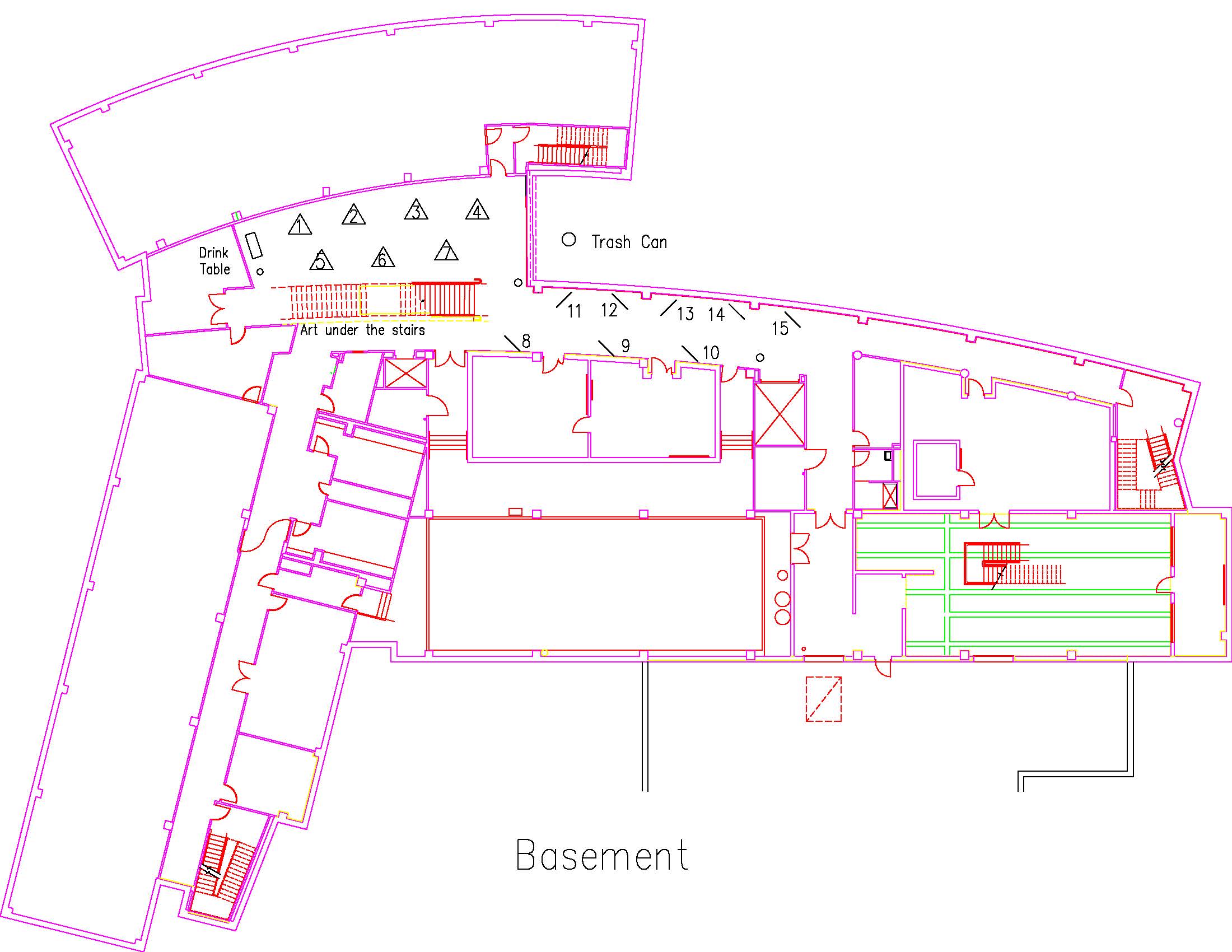
Location: Session: 1; Basement; Table Number: 4
View PresentationUrban Heat Islands (UHI) describe a phenomenon of increasing ambient temperature in densely built areas of cities as compared to rural areas. Impervious cover, ubiquitous in urban areas, appears to absorb solar radiation and reemit that radiation as heat. Urbanization and UHIs have impacts that range from local to global scales and can be found in cities of all sizes and climatic regions (Fernando 2013). This study focused on Tarrant County, Texas and analyzed changes in impervious surface cover and average monthly temperatures at four different NOAA weather monitoring stations over approximately 60 years in a search for urban heat island effect. Temperature analysis indicates an increase in temperature over the 60-year period. This study aims to determine whether that temperature increase is due to UHI.
ENSC2019DUCHARME26150 ENSC
A Changing Urban Ecosystem: Seattle, Washington
Type: Undergraduate
Author(s):
Claire Ducharme
Geological Sciences
Advisor(s):
Tamie Morgan
Geological Sciences
Location: Session: 1; Basement; Table Number: 3
View PresentationThe Urban Heat Island effect, or UHI, describes a phenomena involving heighted temperature indices in metropolitan areas when compared to surrounding rural landscapes. An increasingly relevant area of study following the advent of global warming, today, the associated “infernos” plaguing urban landscapes across the globe have the capacity to seep beyond concrete jungle walls, to reap havoc on once lush and vibrant vegetation and ecosystems. The following analysis combines an understanding of the Urban Heat Island effect with Remote Sensing technologies and Landsat Aerial Imagery to uncover the impact of urbanization in Seattle, Washington. With an emphasis on illustrating change over time, historical data surrounding imaging and climate trends further support this GIS analysis of vegetation in Seattle.
ENSC2019HALL12981 ENSC
Elevation analysis of Foster and Overton parks for radio-tracking bats
Type: Graduate
Author(s):
Ellen Hall
Environmental Sciences
Advisor(s):
Victoria Bennett
Environmental Sciences
Tamie Morgan
Geological Sciences
Location: Session: 1; 1st Floor; Table Number: 1
(Presentation is private)Bats are critical to their surrounding environment, thus we need to know what resources bats need to survive, such as water. Many available water resources in urban areas are ephemeral and dry up during the hot Texas summers. We explored bat resource use in an urban environment by radio-tracking bats in local Fort Worth parks, Foster Park and Overton Park. We used Lidar and 3D mapping in ArcGIS 10.6 to portray our study site where bats were tracked. Using digital elevation, we evaluated high elevation points in the parks that can be used in conducting future surveys.
ENSC2019HINTON16070 ENSC
Water Level Analysis of Lake Mead
Type: Undergraduate
Author(s):
Reed Hinton
Environmental Sciences
Advisor(s):
Tamie Morgan
Geological Sciences
Location: Session: 1; Basement; Table Number: 9
(Presentation is private)Water resources are critical to areas experiencing urbanization and a rapidly increasing population. The depletion of these resources due to either human usage or environmental factors has the potential to lead to water scarcity in surrounding areas. A GIS analysis was conducted on Lake Mead near Las Vegas to assess the change in water level over time.
ENSC2019HOOD26539 ENSC
GIS Analysis of Healthcare Deserts in the Permian Basin
Type: Graduate
Author(s):
Adam Hood
Biology
Advisor(s):
Tamie Morgan
Geological Sciences
Location: Session: 2; 3rd Floor; Table Number: 9
(Presentation is private)Healthcare deserts are an emerging problem in the United States, especially in rural areas. Individuals in these areas do not have access to adequate healthcare, and in most cases they are forced to travel long distances to receive the care they need. In the Permian Basin, this can be of concern for those working in the oil industry as well as their families. A GIS analysis was conducted to identify healthcare deserts in this area.
ENSC2019LAM12347 ENSC
Converting Spent Coffee Grounds into Carbon-Based Materials For Water Treatment
Type: Undergraduate
Author(s):
Amy Lam
Environmental Sciences
Olivia Jones
Environmental Sciences
Todd Longbottom
Geological Sciences
Advisor(s):
Omar Harvey
Geological Sciences
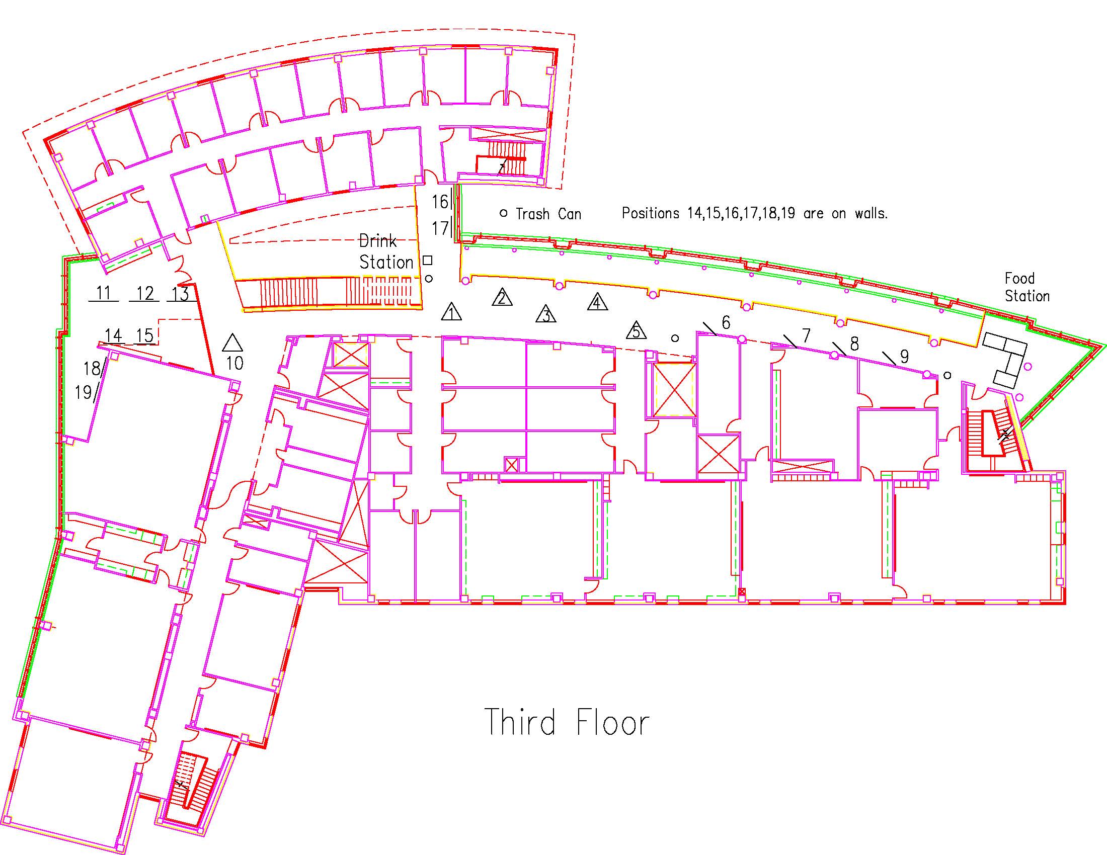
Location: Session: 1; 3rd Floor; Table Number: 8
(Presentation is private)Coffee is one of the most popular drinks in the world. Americans generate on average 12600 tons (around a thousand school buses) of coffee grounds per day – which is most often landfilled. This typical waste stream represents a potential feedstock for developing carbon-based materials with applications across numerous disciplines. For example, initial research in Dr. Harvey’s Lab on spent coffee grounds, received from Avoca Coffee Roasters in Fort Worth, has shown that charring the grounds at 350 ℃ improved its Lead removal abilities. Our research will build upon this previous research by conducting more controlled studies to evaluate those earlier results and determine the optimal charring temperature for producing charcoals for water filtration applications. Since we had no control over how the previously donated coffee grounds were brewed by Avoca Coffee Roasters, we decided to design an experiment that will give us more control over the brewing process. The coffee beans were obtained from Avoca Coffee Roasters and brewed according to the Golden Ratio. We will also study the surface properties of charred coffee grounds produced at 350 ℃, 450 ℃, and 650 ℃ from Ethiopian and Mexican coffee grounds.
ENSC2019MARTINEZ48752 ENSC
Water Clarity of Texas Lakes Before and After Zebra Mussel Infestation
Type: Graduate
Author(s):
Julianna Martinez
Biology
Advisor(s):
Michael Misamore
Biology
Tamie Morgan
Geological Sciences
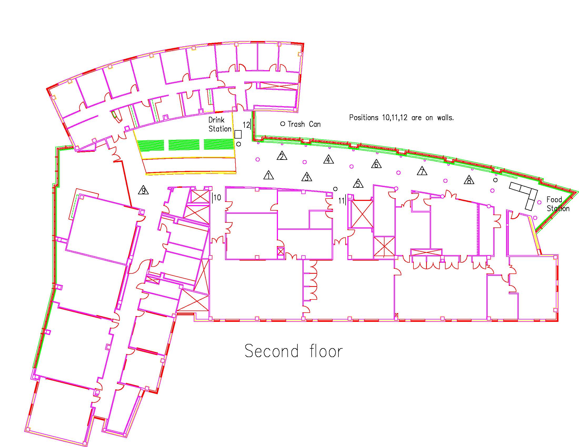
Location: Session: 2; Basement; Table Number: 3
(Presentation is private)Zebra mussels, Dreissena polymorpha, are an invasive species of freshwater bivalves that have recently spread into bodies of water across North America. Zebra mussels inhabit the shallow waters of lakes and tightly attach to any and all hard surfaces. They are efficient filter feeders and can filter up to 1 L of water per day per mussel. This increases the clarity of water dramatically which alters the lake habitat for other lake species. In this analysis, water clarity data was mapped for “infested” lakes for the years 2008 (pre-zebra mussels), 2010 (one year after zebra mussel infestation), and 2016 (seven years after infestation). The average clarity of the lakes increased by 9.36%, with larger lake clarity increasing the most dramatically.
ENSC2019MCQUEEN16945 ENSC
Ghost surveillance: The importance of monitoring acoustic activity in bat diversity hotspots.
Type: Graduate
Author(s):
Martin McQueen
Environmental Sciences
Advisor(s):
Victoria Bennett
Environmental Sciences
Location: Session: 1; 3rd Floor; Table Number: 7
View PresentationHabitat loss, disease, and land-use change has led to a sudden decline in bat populations in the US. Thus, there is a need to determine the extent of the impact before we can effectively implement counter-measures. One way to assess the impacts is to monitor areas with a high abundance and species diversity, such as Big Bend National Park with 25 of the U.S.’s 47 native bat species. We therefore assessed whether 1) acoustic monitoring at the park was a feasible technique and 2) if the diversity of species recorded and their activity patterns could contribute to national long-term monitoring.
ENSC2019NIYITANGAMANZI41060 ENSC
An analysis of factors that influence major crops productivity in Rwanda
Type: Undergraduate
Author(s):
Aurore Niyitanga Manzi
Environmental Sciences
Advisor(s):
Tamie Morgan & Dr. Omar Harvey
Environmental Sciences
Location: Session: 2; 3rd Floor; Table Number: 5
View PresentationA GIS and remote sensing analysis of Rwanda was conducted to analyze changes in land cover, urbanization, and croplands over time. Data mapping changes in major crops productivity throughout time was also analyzed and combined with information on elevation and soil conditions. All factors were analyzed to identify the location and suitability of soils for each major crop.
ENSC2019PAYBLAS51093 ENSC
Spatial and Temporal Variation in Nitrate Contamination as a Function of Well Depth in the Seymour Aquifer
Type: Graduate
Author(s):
Caitlin Payblas
Environmental Sciences
Advisor(s):
Omar Harvey
Geological Sciences
Location: Session: 1; 1st Floor; Table Number: 2
View PresentationNitrate contamination of groundwater in the Seymour Aquifer is a well-known issue that has been documented since the 1960's. Concentrations as high as 35 ppm NO3-N have been reported, which is a startling 3.5 times the EPA allowable standard for drinking water. While most water from the Seymour Aquifer is used for agricultural irrigation, a portion is still used for domestic purposes and therefore poses a risk to human health. While this problem may have been recognized, the specific source of this contamination remains unknown. Three potential sources of nitrate within the aquifer are being considered in this study—the geological makeup of the aquifer, the agricultural contribution of nitrate from fertilizers, and the historical land use change of the area above the aquifer.
My research will combine various statistical and geospatial technologies in order to 1) view nitrate contamination as a function of well depth and 2) Determine the temporal change in NO3-N concentrations over a distribution of well depth. Readily available groundwater quality data from the Texas Water Development Board will be used in conjunction with geospatial analysis and statistical analysis to identify well depth distribution and changes in the aquifer's water quality with respect to well depth over time. After a thorough analysis of the site area via the aforementioned methods and technologies, a portrait that depicts the both spatial and temporal changes of nitrate contamination in Texas's Seymour Aquifer ought to be painted.
ENSC2019PORTILLO33835 ENSC
Investigating the Longterm Effects of Urbanization on Soil Properties in Fort Worth, Tx
Type: Undergraduate
Author(s):
Jacob Portillo
Environmental Sciences
Kelby Caplinger
Environmental Sciences
Michaela Donahoo
Geological Sciences
Dorothy Gilliam
Environmental Sciences
Ella Hellessey
Environmental Sciences
Wyly Lincoln
Environmental Sciences
Aurore Manzi
Environmental Sciences
Advisor(s):
Omar Harvey
Geological Sciences
Location: Session: 2; 2nd Floor; Table Number: 8
View PresentationThe long term effects of urbanization on soil properties in Fort Worth, Texas remain largely unknown, making future predictions of soil health and the development of environmentally beneficial practices difficult. The rapid expansion of the Fort Worth Metroplex begs the question of how can cities best prepare for or mitigate the effects of disturbance due to construction and constant lawn care. In order to understand how soil properties change with time after an initial disturbance, many different methods were implemented to quantify and qualify the different stages of post-urbanized recovery in order to find the trend the soils at the houses of varying age ranges took relative to the natural area. Overall, the soil properties trended towards recovery and the deviation from the natural park area decreased as the houses increased with age. The only variable that did not follow this trend was amount of organic matter at each site, which was determined to be affected uniquely by lawn care and the continued use and accumulation of nutrients from fertilizer applications. These results can be used to identify and understand the effects caused by future construction projects and possibly be used to establish more sustainable development in the DFW area.
ENSC2019SMITH22883 ENSC
Assessing the potential impacts of transmitters on bat flight and behavior in a controlled environment using 3D technology.
Type: Graduate
Author(s):
Kathryn Smith
Environmental Sciences
Advisor(s):
Victoria Bennett
Environmental Sciences
Location: Session: 1; 3rd Floor; Table Number: 5
View PresentationTelemetry is an effective method for collecting movement data, however, transmitters have the potential to negatively impact the maneuverability and behavior of wildlife, particularly volant species. Despite concerns, no studies have assessed the potential effect of transmitters on bats. Thus, we conducted a behavioral study on evening bats (Nycticeius humeralis) in a controlled environment. We found that while there was not a decrease maneuverability, it did alter behavior. Bats flew 79.5% less with the transmitter attached. Furthermore, these impacts did not diminish over time (3 day period), which in turn could have consequences for telemetry survey data collection and interpretation.